Recap: I visited the country’s hottest and driest national park on a road trip with my dog, driving through miles of desolate, flat desert surrounded by mountain ranges. You can read about my experiences at Zion National Park with my dog here.
History
The national park, covering areas of California and Nevada, stretches over 5,000 square miles of the vast Death Valley. It was designated as a national monument in 1933. At that time the area contained the homeland of the Timbisha Shoshone Tribe, and a reservation was not designated for these people until 1982. Death Valley gained national park status in 1994.
The “Death” in Death Valley
Death Valley gets its spooky name from gold rush pioneers heading to California who thought the area would be their tomb in the winter of 1849. When they were rescued and leaving the area, one of them apparently said, “Goodbye, Death Valley,” and the name stuck.
People have lost their lives in the park, with the most common reason being vehicular accidents, and some people have lost their lives due to heat exposure. Temperatures in the hottest place on earth can soar as high as 120 degrees Fahrenheit, with the record high temperature reaching 134 degrees Fahrenheit.

When I visited in April, it was only a cool 87 degrees.

Furnace Creek Visitor Center
Driving Through
Death Valley is a great national park for driving through. Its unique desert landscape stretches for miles, crossing some of the west’s most remote areas.
I entered Death Valley from the east, driving in from Las Vegas through Pahrump and Death Valley Junction, then continued west through Furnace Creek and Panamint Springs on my way to Bishop, California, which I wrote about here.
One famous site is Badwater Basin, which is 282 feet below sea level, consisting of nearly 200 square miles of salt flats made up of salt, calcite, gypsum, and borax. Tens of thousands of years ago this was the site of the ancient Lake Manly, which is now completely evaporated, leaving behind the Badwater Basin.
One of the most popular spots in the park to stop and take in the view is Zabriskie Point. This location is where you can access the start of the Badlands Loop Trail from the parking lot. I had initially put Zabriskie Point on my list to check out, but as I approached the area, I decided to just drive on past. It was pretty crowded, with a line of cars going in and out of the parking lot, and it was crawling with tourists. Not that I have anything against tourists…I realize that most places I go, I’m the tourist! But sometimes when I’m in the middle of a road trip like I was here, the thought of getting to my next stop is all the mental energy I have, and I just don’t want to take the time to futz with a busy crowd.
I did stop at the Father Crowley Vista Point with its views of Rainbow Canyon, where military fighter jets used to train. It’s located near the park’s western edge, overlooking Rainbow Canyon.

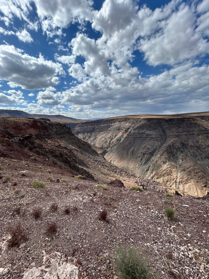
Rainbow Canyon, also known as Star Wars Canyon, was once a training site for fighter jets.

My traveling Tacoma at Father Crowley Vista Point.
Dogs
Pets are not allowed on any trail in Death Valley NP. There are no dog-friendly hikes available in Death Valley. That works for me and Beatrix, because she’s a little old lady who doesn’t really go on hikes and is content to be a passenger princess for the duration. But for many people who have active dogs, this is limiting.
Like all national parks, dogs are allowed on parking lots and paved roads only.
The National Park Service published this list of roads near popular Death Valley sites where you can walk your dog.
Death Valley was a memorable drive through some gorgeous country, and I’m glad I passed through on my way to continue my road trip west!
